If you ask any seasoned drone pilot, they will tell you there is always one unknown variable to every operation, the interactions with the public. These interactions range from welcoming or curious to hostile aggravation and seemingly changes at the drop of a hat. While emotional states are unpredictable, there are usually some common questions you can prepare for: How long does the drone fly? How far can it go? What are you inspecting? And so on. One comment heard constantly which drives us crazy “I just bought my son or daughter a drone” or “Looks like a fun toy!” Thanks to the ubiquity of smaller, cheaper drones, the public has been granted more freedom to the airspace than ever before. The unfortunate side effect is recreational drones are flooding the marketplace and with that comes a host of individuals who now ‘side hustle’ as a drone pilot. Don’t get me wrong, I am not slamming side hustling. In fact, I deeply respect the people who work multiple jobs to make their way, but, as someone who has been in the industry for as long as I have, there are a lot more drone companies today making bombastic claims about their capabilities and frankly doing horrendous work. This hurts our industry’s reputation and leaves our clientele scarred. This article is here for anyone considering hiring a drone team for a building façade inspection, new or seasoned drone pilots, and the engineers looking at the data. I want to arm you with a fundamental understanding of the differences from a small, consumer drone to an enterprise drone, the dangers of hiring a non-specialized drone team to do a façade inspection, and how to protect yourself from hiring a team who overpromises and underdelivers.
Recreational vs Enterprise Drones (and pilots)
Before we dive deep into the drones, it’s important to build a picture of what a building façade inspection would entail. Most likely, the building will be surrounded by a large number of obstacles: trees, poles, signs, other buildings, etc. Also, there will likely be pedestrian traffic on the ground. The remote pilot in command for the project must be able to navigate all obstacles, properly close pedestrian walkways beneath the active drone, achieve pictures of the entire building (either manually or autonomously), and most importantly do all of this safely. So ask yourself this: with a large number of obstacles and pedestrians, does the person flying your project have a drone with proper obstacle avoidance measures? If not, everyone involved is playing a very dangerous game. To be clear, obstacle avoidance is not a standard feature for most drones. Drones with obstacle avoidance decrease the percentage of crashing by ten-fold since it will sense objects nearby and stop the drone, even if the pilot gives full-throttle in the direction of the object. Compare this to a pilot who is manually flying his drone. Every object is a potential factor for collision and catastrophe.
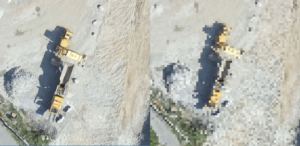
This leads into cameras and quality. Without getting into the weeds on cameras, I want to highlight one important aspect specifically for inspection purposes: ground sampling distance (GSD) as seen in the picture below in exhibit 1.
Exhibit 1: Low GSD on the left and high GSD on the right

As seen above, the lower the GSD, the higher the clarity of the photos. When inspecting a building, you want the lowest GSD possible to help find the tiniest of hairline fractures, which are extremely valuable to structural engineers. The main contributing factors to achieve a low GSD is distance from the object and the type of camera. Now this gets a little technical but, stay with me because this is very important. The camera we use is a 48-megapixel full-frame camera which is around 2 millimeters GSD at 50 feet away from an object. The 2 millimeters represents the space on the surface being imaged. Common camera pixel ranges on recreational drones are about 20 megapixels and 1/2 inch sensor. That means the common camera would need to be around 5 feet away from the building to collect the same quality data our cameras get at 50 feet distance! All of this is to say that a recreational drone camera will miss defects simply because the camera is not advanced enough to pick them up.
An astute person may say, “just fly closer to the building then”. Well, flying closer to the building is problematic. The closer to the building, the more prone the drone is to losing GPS positioning, especially ones with lower quality antennas. If GPS positioning is lost, the drone either stops and hovers/drifts, continues the mission without GPS positioning (atti mode), activates a return to home function (as seen in this video at minute 5:27), or activates a landing sequence. It is the worst-case scenario losing GPS with a limited amount of space between you and the building, that is why it important to have a high-quality camera to give pilots some breathing room and avoid crashing the drone into the building, surrounding obstacles, or even people.
Other Considerations
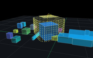
“How will the data be collected” is a deeply important question to ask. Data collection is the difference between capturing the building in its entirety in one go or having to go back out to recollect because there are missing sections or simply unusable data. I will go out on a limb and say most new drone companies do not implement advanced flight planning, as seen below in exhibit 2.
Exhibit 2: Flight planning software

Flight software has three massive advantages. First, we can anticipate obstacles therefore know where to supplement ground photos. Second, we eliminate the guesswork of “Did I capture this area?” No one wants to go back to the field to capture missing areas, costing more time and money. Lastly, automation means the data will be consistent, especially compared with manually flying.
Once the data is captured, the next question is what does the other drone company do with the data they just collected? Well, you’re not going to like the answer, unless you like pouring through thousands of photos looking for small cracks. Most of the time, drone providers will just send you a bunch of raw .jpeg images. At 1-Day Inspections, we don’t leave you with thousands of images that need to analyzed. We do the hard work for you and bring the most advanced AI technology to the table. Our partner’s AI technology analyzes the data for defects, then annotates the defects for you to be viewed on a digital 3-D model. The impressive AI can also measure each crack found down to less than 1 millimeter, which is unheard of current building inspection methods. On top of all this, you now have a baseline for your assets with automated collection mapping for future use so you can track how these structures are changing over time.
Protect Yourself
At 1-Day Inspections, we are of the few drone companies who specialize in building exterior and roof inspections and strive to be your trusted friend in this space. If the choice is not us, which would make me really sad since we’ve spent the time in this article together, then I hope I have at least armed you with important questions to ask other drone companies while researching the best options for your building’s façade inspections.
Dylan Robbins,
Founder & President, 1-Day Inspections
